
Thank you for supporting this site ❤️
Make a donation
Make a donation
Ingwavuma topographic map
Click on the map to display elevation.
Thank you for supporting this site ❤️
Make a donation
Make a donation
About this map
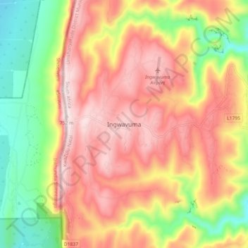
Name: Ingwavuma topographic map, elevation, terrain.
Average elevation: 500 m
Minimum elevation: 203 m
Maximum elevation: 750 m
Thank you for supporting this site ❤️
Make a donation
Make a donation
Other topographic maps
Click on a map to view its topography, its elevation and its terrain.
Manyoni Private Game Reserve
South Africa > KwaZulu-Natal > Umkhanyakude District Municipality > Jozini Local Municipality
Average elevation: 274 m