
Make a donation
Plettenberg topographic map
Click on the map to display elevation.
Make a donation
Plettenberg
Plettenberg is located to the west of the Sauerland hills. The highest elevation of the town area is in the Ebbe Mountains with 663 m above sea level, the lowest elevation with 194 m near Teindeln [de]. The town is spread out between the four valleys of the rivers Lenne, Else, Oester [arz; ceb; cv; de; zh] and Grüne [ceb].
Make a donation
About this map
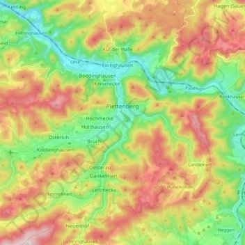
Name: Plettenberg topographic map, elevation, terrain.
Average elevation: 378 m
Minimum elevation: 186 m
Maximum elevation: 630 m
Make a donation
Other topographic maps
Click on a map to view its topography, its elevation and its terrain.
Rotthausen
Germany > North Rhine-Westphalia > Märkischer Kreis > Schalksmühle
Average elevation: 343 m
Gelstern
Germany > North Rhine-Westphalia > Märkischer Kreis > Schalksmühle > Heedfeld
Average elevation: 385 m
Moßberg
Germany > North Rhine-Westphalia > Märkischer Kreis > Menden (Sauerland)
Average elevation: 220 m
Make a donation
Blechen
Germany > North Rhine-Westphalia > Märkischer Kreis > Kierspe > Blechen
Average elevation: 376 m