
Thank you for supporting this site ❤️
Make a donation
Make a donation
Nanning topographic map
Click on the map to display elevation.
Thank you for supporting this site ❤️
Make a donation
Make a donation
Nanning
Nanning is located in the southern part of the Guangxi Zhuang Autonomous Region, 160 km (99 mi) from the border with Vietnam. It has an administrative area of 22,293 km2 (8,607 sq mi). Nanning is situated in a hilly basin with elevations between 70 and 500 m (230 and 1,640 ft) above sea-level. Qingxiu Mountain dominates the southern part of town.
Thank you for supporting this site ❤️
Make a donation
Make a donation
About this map
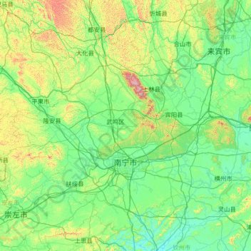
Name: Nanning topographic map, elevation, terrain.
Location: Nanning, Guangxi, China (22.20652 107.32456 24.03478 109.61818)
Average elevation: 225 m
Minimum elevation: 10 m
Maximum elevation: 1,721 m
Thank you for supporting this site ❤️
Make a donation
Make a donation