
Sëlva - Wolkenstein - Selva di Val Gardena topographic map
Interactive map
Click on the map to display elevation.
Sëlva - Wolkenstein - Selva di Val Gardena
Sëlva is characterized by a typical Alpine climate. Summers are rather short and relatively wet. The average daily temperatures in summer lie between 18 and 21 °C, while at night temperatures usually drop to between 6 and 9 °C. Winters are typically cold, long and relatively dry. The average daily temperatures in winter lie between 0 and 2 °C, while at night temperatures usually drop to between -6 and -9 °C. The wettest month is August with 142 mm, while the driest is February with only 21 mm. This data was measured at the weather station in Plan at an altitude of 1,594 metres between 1991 and 2020.
About this map
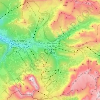
Name: Sëlva - Wolkenstein - Selva di Val Gardena topographic map, elevation, terrain.
Average elevation: 2,118 m
Minimum elevation: 1,268 m
Maximum elevation: 3,179 m