
Grisons topographic map
Interactive map
Click on the map to display elevation.
About this map
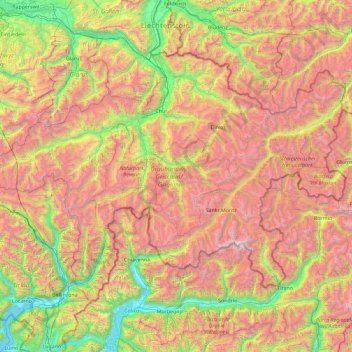
Name: Grisons topographic map, elevation, terrain.
Location: Grisons, Switzerland (46.16918 8.65106 47.06515 10.49229)
Average elevation: 1,737 m
Minimum elevation: 189 m
Maximum elevation: 4,001 m
The Grisons lies fully within the Alps, with elevations above sea-level ranging from 260 to 4,049 metres (853 to 13,284 ft). It is both one of the highest and lowest cantons, and the second-highest when considering mean elevation. As a consequence, its topography is extremely rugged and many of the highest settlements in the country (and Europe) are found there, notably in the Upper Engadin. The mountains are numerous; well over 1,000 summits are in the canton. The highest is Piz Bernina, closely followed by numerous peaks in the homonymous range. Other prominent mountains are Piz Russein, Piz Kesch, Calanda, Aroser Rothorn and Rheinwaldhorn, see list of mountains of Graubünden for a more exhaustive list. The canton includes numerous subranges of the Alps other than the Bernina. These are the Albula, the Bregaglia, the Glarus, the Gotthard, the Lepontine, the Livigno, the Plessur, the Oberhalbstein, the Ortler, the Rätikon, the Samnaun, the Sesvenna and the Silvretta ranges.
Other topographic maps
Click on a map to view its topography, its elevation and its terrain.
Kiental
Switzerland > Bern > Frutigen-Niedersimmental administrative district > Reichenbach im Kandertal
Kiental, Reichenbach im Kandertal, Frutigen-Niedersimmental administrative district, Oberland administrative region, Bern, 3723, Switzerland
Average elevation: 1,363 m
Burgers
Switzerland > Appenzell Innerrhoden > Schwende-Rüte > Schwende
Burgers, Schwende, Schwende-Rüte, Appenzell Innerrhoden, 9057, Switzerland
Average elevation: 941 m
Wengen
Switzerland > Bern > Interlaken-Oberhasli administrative district
Wengen, Lauterbrunnen, Interlaken-Oberhasli administrative district, Oberland administrative region, Bern, 3823, Switzerland
Average elevation: 1,450 m
Brienz
Switzerland > Bern > Interlaken-Oberhasli administrative district > Brienz (BE)
Brienz, Brienz (BE), Interlaken-Oberhasli administrative district, Oberland administrative region, Bern, 3855, Switzerland
Average elevation: 810 m
Neuhausen am Rheinfall
Neuhausen am Rheinfall, Schaffhausen, 8212, Switzerland
Average elevation: 450 m
Aarau
Switzerland > Aargau > Bezirk Aarau
Aarau, Bezirk Aarau, Aargau, 5000, Switzerland
Average elevation: 421 m
Gamsberg
Switzerland > St. Gallen > Wahlkreis Werdenberg > Grabs
Gamsberg, Grabs, Wahlkreis Werdenberg, St. Gallen, 8892, Switzerland
Average elevation: 1,836 m
Rosablanche
Switzerland > Wallis > Hérens > Hérémence
Rosablanche, Hérémence, Hérens, Wallis, 1987, Switzerland
Average elevation: 2,952 m
Underburg
Switzerland > Bern > Interlaken-Oberhasli administrative district > Innertkirchen > Wychel
Underburg, Wychel, Innertkirchen, Interlaken-Oberhasli administrative district, Oberland administrative region, Bern, 3862, Switzerland
Average elevation: 912 m
La Chaux-du-Milieu
Switzerland > Neuchâtel > La Chaux-du-Milieu
La Chaux-du-Milieu, Neuchâtel, 2405, Switzerland
Average elevation: 1,106 m
Under Tanneboumgrabe
Switzerland > Bern > Interlaken-Oberhasli administrative district > Unterseen > Tanneboum
Under Tanneboumgrabe, Luziwichel, Tanneboum, Unterseen, Interlaken-Oberhasli administrative district, Oberland administrative region, Bern, 3800, Switzerland
Average elevation: 862 m
Vex
Switzerland > Wallis > Hérens > Vex
Vex, Hérens, Wallis, 2305, Switzerland
Average elevation: 1,285 m
Vernier
Switzerland > Geneva > Vernier
Vernier, Grand Genève, Geneva, Switzerland
Average elevation: 412 m
Trient
Switzerland > Valais/Wallis > Trient
Trient, Martigny, Valais/Wallis, 1929, Switzerland
Average elevation: 2,018 m
Andermatt
Switzerland > Uri > Andermatt
Andermatt, Korporation Ursern, Uri, 6490, Switzerland
Average elevation: 2,127 m
Davos
Switzerland > Grisons > Davos
Davos, Prättigau/Davos, Grisons, Switzerland
Average elevation: 2,142 m
Boncourt
Switzerland > Jura > Boncourt
Boncourt, District de Porrentruy, Jura, 2926, Switzerland
Average elevation: 444 m
Koppigen
Switzerland > Bern > Koppigen
Koppigen, Verwaltungskreis Emmental, Verwaltungsregion Emmental-Oberaargau, Bern, 3425, Switzerland
Average elevation: 480 m
Martigny-Combe
Switzerland > Valais/Wallis > Martigny-Combe
Martigny-Combe, Martigny, Valais/Wallis, 1921, Switzerland
Average elevation: 1,472 m
Charmey
Switzerland > Fribourg > Val-de-Charmey
Charmey, Val-de-Charmey, Gruyère District, Fribourg, 1637, Switzerland
Average elevation: 1,299 m
Prayon
Switzerland > Valais/Wallis > Prayon
Prayon, Entremont, Valais/Wallis, 2303, Switzerland
Average elevation: 1,924 m
Leukerbad
Switzerland > Valais/Wallis > Leukerbad
Leukerbad, Leuk, Valais/Wallis, 3954, Switzerland
Average elevation: 2,299 m
Leytron
Switzerland > Valais/Wallis > Leytron
Leytron, Martigny, Valais/Wallis, Switzerland
Average elevation: 1,291 m
Sion
Switzerland > Valais/Wallis > Sion
Sion, Valais/Wallis, 1950, Switzerland
Average elevation: 818 m
Fully
Switzerland > Valais/Wallis > Fully
Fully, Martigny, Valais/Wallis, 1926, Switzerland
Average elevation: 1,390 m
Dorénaz
Switzerland > Valais/Wallis > Dorénaz
Dorénaz, Saint-Maurice, Valais/Wallis, 1905, Switzerland
Average elevation: 1,027 m
Finhaut
Switzerland > Valais/Wallis > Finhaut
Finhaut, Saint-Maurice, Valais/Wallis, 1925, Switzerland
Average elevation: 1,730 m
Anniviers
Switzerland > Valais/Wallis > Anniviers
Anniviers, Sierre, Valais/Wallis, 3961, Switzerland
Average elevation: 2,310 m
Bienne
Switzerland > Bern > Bienne
Bienne, Verwaltungskreis Biel/Bienne, Verwaltungsregion Seeland, Bern, Switzerland
Average elevation: 655 m
La Sagne
Switzerland > Neuchâtel > La Sagne
La Sagne, District de La Chaux-de-Fonds, Neuchâtel, 2314, Switzerland
Average elevation: 1,132 m
Val-de-Travers
Switzerland > Neuchâtel > Val-de-Travers
Val-de-Travers, District du Val-de-Travers, Neuchâtel, Switzerland
Average elevation: 1,040 m
Ittigen
Switzerland > Bern > Ittigen
Ittigen, Verwaltungskreis Bern-Mittelland, Verwaltungsregion Bern-Mittelland, Bern, Switzerland
Average elevation: 595 m
Lenk
Switzerland > Bern > Lenk
Lenk, Verwaltungskreis Obersimmental-Saanen, Verwaltungsregion Oberland, Bern, 3775, Switzerland
Average elevation: 1,931 m
Rüeggisberg
Switzerland > Bern > Rüeggisberg
Rüeggisberg, Verwaltungskreis Bern-Mittelland, Verwaltungsregion Bern-Mittelland, Bern, Switzerland
Average elevation: 970 m
Villeret
Switzerland > Bern > Villeret
Villeret, Arrondissement administratif du Jura bernois, Bern, 2613, Switzerland
Average elevation: 1,084 m
Reconvilier
Switzerland > Bern > Reconvilier
Reconvilier, Arrondissement administratif du Jura bernois, Bern, 2732, Switzerland
Average elevation: 903 m
Brienz (BE)
Switzerland > Bern > Brienz (BE)
Brienz (BE), Verwaltungskreis Interlaken-Oberhasli, Verwaltungsregion Oberland, Bern, Switzerland
Average elevation: 1,448 m
Steffisburg
Switzerland > Bern > Steffisburg
Steffisburg, Verwaltungskreis Thun, Verwaltungsregion Oberland, Bern, Switzerland
Average elevation: 697 m
Eysins
Switzerland > Vaud > Eysins
Eysins, District de Nyon, Vaud, 1262, Switzerland
Average elevation: 443 m
Col de Jaman
Switzerland > Vaud > Montreux
Col de Jaman, , Chalet des Chèvres, Montreux, District de la Riviera-Pays-d’Enhaut, Vaud, 1833, Switzerland
Average elevation: 1,464 m
Montreux
Switzerland > Vaud > Montreux
Montreux, District de la Riviera-Pays-d’Enhaut, Vaud, Switzerland
Average elevation: 820 m
L'Abbaye
Switzerland > Vaud > L'Abbaye
L'Abbaye, District du Jura-Nord vaudois, Vaud, Switzerland
Average elevation: 1,171 m
Mont-la-Ville
Switzerland > Vaud > Mont-la-Ville
Mont-la-Ville, District de Morges, Vaud, 1148, Switzerland
Average elevation: 930 m
Chardonne
Switzerland > Vaud > Chardonne
Chardonne, District de la Riviera-Pays-d’Enhaut, Vaud, Switzerland
Average elevation: 737 m