
Dall Island topographic map
Interactive map
Click on the map to display elevation.
About this map
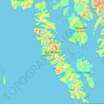
Name: Dall Island topographic map, elevation, terrain.
Location: Dall Island, Prince of Wales-Hyder, Alaska, USA (54.66173 -133.23958 55.26379 -132.66238)
Average elevation: 62 m
Minimum elevation: -7 m
Maximum elevation: 1,123 m
Other topographic maps
Click on a map to view its topography, its elevation and its terrain.
Mendenhaven
USA > Alaska > Mendenhaven
Mendenhaven, Juneau, Alaska, 99801, USA
Average elevation: 126 m
Matanuska Glacier
Matanuska Glacier, Matanuska-Susitna, Alaska, USA
Average elevation: 1,819 m
Shadows Glacier
Shadows Glacier, Matanuska-Susitna, Alaska, USA
Average elevation: 1,464 m
Revillagigedo Island
Revillagigedo Island, Ketchikan Gateway, Alaska, USA
Average elevation: 342 m
Byron Glacier
Byron Glacier, Byron Glacier Trail, Anchorage, Alaska, USA
Average elevation: 749 m
Kanikula Glacier
Kanikula Glacier, Matanuska-Susitna, Alaska, USA
Average elevation: 1,606 m
Mitkof Island
Mitkof Island, Petersburg Borough, Alaska, 99833, USA
Average elevation: 154 m
Kennicott Glacier
Kennicott Glacier, Valdez-Cordova, Alaska, USA
Average elevation: 1,845 m
Chenega Glacier
Chenega Glacier, Unorganized Borough, Alaska, USA
Average elevation: 752 m
Worthington Glacier
Worthington Glacier, Richardson Highway, Ptarmigan, Valdez-Cordova, Alaska, USA
Average elevation: 1,356 m