
Thank you for supporting this site ❤️
Make a donation
Make a donation
Winnie Mandela (Brandfort) topographic map
Click on the map to display elevation.
Thank you for supporting this site ❤️
Make a donation
Make a donation
About this map
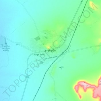
Name: Winnie Mandela (Brandfort) topographic map, elevation, terrain.
Average elevation: 1,403 m
Minimum elevation: 1,361 m
Maximum elevation: 1,590 m
Thank you for supporting this site ❤️
Make a donation
Make a donation
Other topographic maps
Click on a map to view its topography, its elevation and its terrain.
Erfenis Dam
South Africa > Free State > Lejweleputswa District Municipality > Masilonyana Local Municipality
Average elevation: 1,356 m
HJ Joel Nature Reserve
South Africa > Free State > Lejweleputswa District Municipality > Masilonyana Local Municipality
Average elevation: 1,386 m
Masilonyana Ward 3
South Africa > Free State > Lejweleputswa District Municipality > Masilonyana Local Municipality
Average elevation: 1,419 m