
Make a donation
Po Valley topographic map
Click on the map to display elevation.
Make a donation
Po Valley
The altitude of the valley through which the Po flows, exclusive of its tributaries, varies from approximately 4 m (15 feet) below sea level in the Polesine subregion (the delta around Ferrara) to about 2,100 m (6,900 feet) at the river's origin in the southern Piedmontese province of Cuneo, also known as the Provincia granda. The valley is crossed by a number of affluents running down from the Alps in the north and from the Apennines in the south. The Po's major affluents include the Tanaro, Scrivia, Trebbia, Panaro and Secchia in the south, Dora Riparia, Dora Baltea, Sesia, Ticino (draining Lake Maggiore), Lambro, Adda (draining Lake Como), Oglio (draining Lake Iseo) and Mincio (draining Lake Garda and called Sarca in its upper reaches) in the north.
Make a donation
About this map
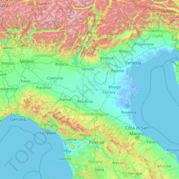
Name: Po Valley topographic map, elevation, terrain.
Location: Po Valley, Italy (44.03882 7.28861 45.84980 12.56358)
Average elevation: 500 m
Minimum elevation: -6 m
Maximum elevation: 3,858 m
Make a donation
Other topographic maps
Click on a map to view its topography, its elevation and its terrain.
Schmieden - Ferrara
Italy > Trentino – Alto Adige/Südtirol > South Tyrol > Prags - Braies
Average elevation: 1,426 m
Cortina
Italy > Trentino – Alto Adige/Südtirol > Provincia di Trento > Vermiglio
Average elevation: 1,534 m
Make a donation
Mount Vesuvius
Italy > Campania > Naples > Trecase
The volcano's slopes are scarred by lava flows, while the rest are heavily vegetated, with scrub and forests at higher altitudes and vineyards lower down.
Average elevation: 862 m
Make a donation
Gran Paradiso
Italy > Aosta Valley > Valsavarenche
The peak is the 7th highest mountain in the Graian Alps, with an elevation of 4,061 m. In the SOIUSA (International Standardized Mountain Subdivision of the Alps) the mountain belongs to an alpine subsection called "North-Eastern Graian Alps" (It:Alpi del Gran Paradiso; Fr:Alpes du Grand-Paradis) and also…
Average elevation: 3,459 m
Make a donation
Matterhorn
Italy > Aosta Valley > Valtournenche
In 1999, the summit height was precisely determined to be at 4,477.54 m (14,690 ft) above sea level by using Global Positioning System technology as part of the TOWER Project (Top of the World Elevations Remeasurement) and to an accuracy of less than one centimetre, which allows future changes to be tracked.
Average elevation: 3,295 m
Make a donation
Erto / Nert
Italy > Friuli – Venezia Giulia > Pordenone / Pordenon > Erto e Casso
Average elevation: 1,112 m
Make a donation
Breuil-Cervinia
The ski area is very large and guarantees good snow quality during the season, being at a high altitude (2,050 m to 3,500 m).
Average elevation: 2,376 m
Make a donation
Make a donation
Make a donation
Monte Pastello
Italy > Veneto > Verona > Fumane
Monte Pastello is a mountain of the Veneto, Italy. The mountain, which has an elevation of 1,128 metres, is part of the Monti Lessini in the Venetian Prealps. It is located in the Province of Verona.
Average elevation: 698 m
Secëda - Monte Seceda
Italy > Trentino – Alto Adige/Südtirol > South Tyrol > Santa Cristina Gherdëina - St. Christina in Gröden - Santa Cristina Valgardena
Monte Seceda is a 2,519-meter-elevation (8,264-foot) summit in the Odles Group of the Dolomites, a UNESCO World Heritage Site. Set in the Trentino-Alto Adige/Südtirol region, the peak is located four kilometers (2.5 miles) north of the village of Santa Cristina Gherdëina, and the peak is in Puez-Geisler…
Average elevation: 2,106 m
Make a donation
Make a donation
Make a donation
Grünsee - Lago Verde
Italy > Trentino – Alto Adige/Südtirol > South Tyrol > Ulten - Ultimo
Average elevation: 2,683 m
Make a donation
Monte Tamai
Italy > Friuli – Venezia Giulia > Udine / Udin / Videm > Ovaro / Davâr
Average elevation: 1,588 m
Make a donation
Mazza di Pichea
Italy > Trentino – Alto Adige/Südtirol > Provincia di Trento
Average elevation: 1,467 m
Make a donation
B o s c o d i M o n t e M i g l i o
Italy > Molise > Isernia > San Pietro Avellana
Average elevation: 1,008 m
Make a donation
Make a donation
Make a donation
Zegla / Ceglo
Italy > Friuli – Venezia Giulia > Gorizia / Gurize / Gorica > Cormons / Cormòns / Krmin
Average elevation: 85 m
Mount Etna
During the first 1500 years AD, many eruptions went unrecorded (or records have been lost); among the more significant are: (1) an eruption in about 1030 AD near Monte Ilice on the lower southeast flank, which produced a lava flow that travelled about 10 km, reaching the sea north of Acireale; the villages of…
Average elevation: 1,157 m
Make a donation
Apennine Mountains
A separate branch, the Apuan Alps, goes southwest, bordering the coast south of La Spezia. Whether they are to be considered part of the Apennines is a matter of opinion; certainly, they are part of the Apennine System. Topographically only the valley of the River Serchio, which running parallel to the coast…
Average elevation: 1,735 m
Make a donation