
Rietvlei Nature Reserve topographic map
Interactive map
Click on the map to display elevation.
About this map
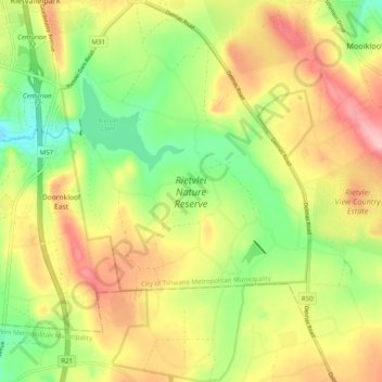
Name: Rietvlei Nature Reserve topographic map, elevation, terrain.
Average elevation: 1,519 m
Minimum elevation: 1,445 m
Maximum elevation: 1,600 m
Rietvlei Nature Reserve, located in southern Pretoria, is about 4,000 hectares (40 km2) in size, and includes the entirety of the Rietvlei Dam which impounds the Rietvlei River, in Gauteng, South Africa. The reserve is wedged between the R21 highway (OR Tambo Airport highway) on the western side and the R50 (Delmas-Bapsfontein) road on the north-east. The mean elevation above sea level is approximately 1,525 meters, with the highest point at 1,542 m and the lowest at 1,473 m, the dam’s outflow in Sesmylspruit. The reserve covers a surface area of approximately 4,003 ha or 40 km2, of which the dam constitutes some 20ha. A network of roads criss-cross the entire area, which facilitates access to visitors and management.
Other topographic maps
Click on a map to view its topography, its elevation and its terrain.
Pretoria
South Africa > Gauteng > City of Tshwane Metropolitan Municipality
Pretoria, City of Tshwane Metropolitan Municipality, Gauteng, 0126, South Africa
Average elevation: 1,363 m
Apies
South Africa > Gauteng > City of Tshwane Metropolitan Municipality > Pretoria
Apies, Pretoria, City of Tshwane Metropolitan Municipality, Gauteng, South Africa
Average elevation: 1,250 m
Kruin Park
South Africa > Gauteng > City of Tshwane Metropolitan Municipality > Pretoria
Kruin Park, Lukasrand, Tshwane Ward 59, Pretoria, City of Tshwane Metropolitan Municipality, Gauteng, South Africa
Average elevation: 1,380 m
Roodeplaat Dam
South Africa > Gauteng > City of Tshwane Metropolitan Municipality
Roodeplaat Dam, City of Tshwane Metropolitan Municipality, Gauteng, South Africa
Average elevation: 1,240 m
Centurion
South Africa > Gauteng > City of Tshwane Metropolitan Municipality
Centurion, City of Tshwane Metropolitan Municipality, Gauteng, 0014, South Africa
Average elevation: 1,451 m
Faerie Glen
South Africa > Gauteng > City of Tshwane Metropolitan Municipality
Faerie Glen, Tshwane Ward 44, City of Tshwane Metropolitan Municipality, Gauteng, South Africa
Average elevation: 1,403 m
Cullinan
South Africa > Gauteng > City of Tshwane Metropolitan Municipality
Cullinan, City of Tshwane Metropolitan Municipality, Gauteng, South Africa
Average elevation: 1,420 m
Tshwane Ward 47
South Africa > Gauteng > City of Tshwane Metropolitan Municipality
Tshwane Ward 47, City of Tshwane Metropolitan Municipality, Gauteng, South Africa
Average elevation: 1,523 m
Bronkhorstspruit Dam
South Africa > Gauteng > City of Tshwane Metropolitan Municipality
Bronkhorstspruit Dam, City of Tshwane Metropolitan Municipality, Gauteng, South Africa
Average elevation: 1,462 m
Faerie Glen Nature Reserve
South Africa > Gauteng > City of Tshwane Metropolitan Municipality > Pretoria
Faerie Glen Nature Reserve, Tshwane Ward 46, Pretoria, City of Tshwane Metropolitan Municipality, Gauteng, South Africa
Average elevation: 1,385 m
Freedom Park
South Africa > Gauteng > City of Tshwane Metropolitan Municipality > Pretoria
Freedom Park, Tshwane Ward 59, Pretoria, City of Tshwane Metropolitan Municipality, Gauteng, South Africa
Average elevation: 1,390 m
Bronkhorstspruit
South Africa > Gauteng > City of Tshwane Metropolitan Municipality
Bronkhorstspruit, City of Tshwane Metropolitan Municipality, Gauteng, 1020, South Africa
Average elevation: 1,411 m
Tshwane Ward 48
South Africa > Gauteng > City of Tshwane Metropolitan Municipality
Tshwane Ward 48, City of Tshwane Metropolitan Municipality, Gauteng, South Africa
Average elevation: 1,363 m
Apies River
South Africa > Gauteng > City of Tshwane Metropolitan Municipality
Apies River, City of Tshwane Metropolitan Municipality, Gauteng, 0001, South Africa
Average elevation: 1,224 m
Irene
South Africa > Gauteng > City of Tshwane Metropolitan Municipality
Irene, City of Tshwane Metropolitan Municipality, Gauteng, 0046, South Africa
Average elevation: 1,478 m
Ezemvelo Nature Reserve
South Africa > Gauteng > City of Tshwane Metropolitan Municipality
Ezemvelo Nature Reserve, Ezemvelo, Tshwane Ward 105, City of Tshwane Metropolitan Municipality, Gauteng, South Africa
Average elevation: 1,360 m
Mamelodi
South Africa > Gauteng > City of Tshwane Metropolitan Municipality
Mamelodi, City of Tshwane Metropolitan Municipality, Gauteng, 0101, South Africa
Average elevation: 1,319 m
Prince's Park
South Africa > Gauteng > City of Tshwane Metropolitan Municipality > Pretoria
Prince's Park, Salvokop, Tshwane Ward 60, Pretoria, City of Tshwane Metropolitan Municipality, Gauteng, South Africa
Average elevation: 1,325 m
Akasia
South Africa > Gauteng > City of Tshwane Metropolitan Municipality
Akasia, City of Tshwane Metropolitan Municipality, Gauteng, 0118, South Africa
Average elevation: 1,309 m
Rayton
South Africa > Gauteng > City of Tshwane Metropolitan Municipality
Rayton, City of Tshwane Metropolitan Municipality, Gauteng, 1001, South Africa
Average elevation: 1,459 m
Centurion Lake
South Africa > Gauteng > City of Tshwane Metropolitan Municipality > Centurion
Centurion Lake, Lyttleton L.H., Tshwane Ward 57, Centurion, City of Tshwane Metropolitan Municipality, Gauteng, South Africa
Average elevation: 1,440 m
Simarlo AH
South Africa > Gauteng > City of Tshwane Metropolitan Municipality
Simarlo AH, City of Tshwane Metropolitan Municipality, Gauteng, 0045, South Africa
Average elevation: 1,462 m