
Northwest Arctic topographic map
Interactive map
Click on the map to display elevation.
About this map
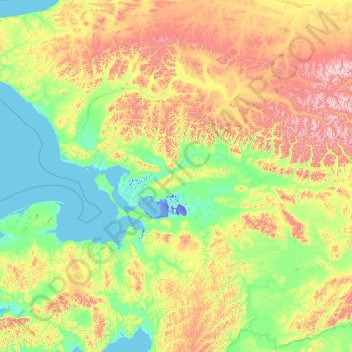
Name: Northwest Arctic topographic map, elevation, terrain.
Location: Northwest Arctic, Alaska, United States of America (65.43586 -165.55557 68.30103 -154.13228)
Average elevation: 296 m
Minimum elevation: -12 m
Maximum elevation: 2,096 m
Other topographic maps
Click on a map to view its topography, its elevation and its terrain.
Sitka
United States of America > Alaska
Sitka, Alaska, 99835, United States of America
Average elevation: 110 m
Aleutians East
United States of America > Alaska
Aleutians East, Alaska, United States of America
Average elevation: 23 m
Yukon-Koyukuk
United States of America > Alaska > Northway
Yukon-Koyukuk, Northway Road, Northway, Unorganized Borough, Alaska, United States of America
Average elevation: 494 m
Southeast Fairbanks
United States of America > Alaska > Eagle
Southeast Fairbanks, Old Camp Road, Eagle, Unorganized Borough, Alaska, 99738, United States of America
Average elevation: 856 m
Lake and Peninsula
United States of America > Alaska
Lake and Peninsula, Alaska, United States of America
Average elevation: 151 m
Bethel
United States of America > Alaska > Bethel > Bethel
Bethel, Unorganized Borough, Alaska, 99559, United States of America
Average elevation: 11 m