
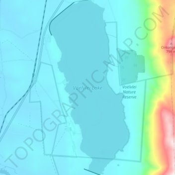
Voëlvlei Lake topographic map
Interactive map
Click on the map to display elevation.
About this map
Name: Voëlvlei Lake topographic map, elevation, terrain.
Average elevation: 159 m
Minimum elevation: 54 m
Maximum elevation: 919 m
Other topographic maps
Click on a map to view its topography, its elevation and its terrain.
Spitskop
South Africa > Western Cape > Cape Winelands District Municipality > Drakenstein Local Municipality
Spitskop, Drakenstein Local Municipality, Cape Winelands District Municipality, Western Cape, South Africa
Average elevation: 694 m
Wemmershoek Dam
South Africa > Western Cape > Cape Winelands District Municipality > Drakenstein Local Municipality
Wemmershoek Dam, Drakenstein Ward 28, Drakenstein Local Municipality, Cape Winelands District Municipality, Western Cape, South Africa
Average elevation: 425 m
Wemmershoek Tafelberg
South Africa > Western Cape > Cape Winelands District Municipality > Drakenstein Local Municipality
Wemmershoek Tafelberg, Drakenstein Local Municipality, Cape Winelands District Municipality, Western Cape, South Africa
Average elevation: 1,292 m
Kromrivier
South Africa > Western Cape > Cape Winelands District Municipality > Drakenstein Local Municipality > Wellington
Kromrivier, Wellington, Drakenstein Local Municipality, Cape Winelands District Municipality, Western Cape, South Africa
Average elevation: 150 m
Gouda
South Africa > Western Cape > Cape Winelands District Municipality > Drakenstein Local Municipality
Gouda, Drakenstein Ward 31, Drakenstein Local Municipality, Cape Winelands District Municipality, Western Cape, South Africa
Average elevation: 83 m
Berg en Dal
South Africa > Western Cape > Cape Winelands District Municipality > Drakenstein Local Municipality > Berg en Dal
Berg en Dal, Drakenstein Local Municipality, Cape Winelands District Municipality, Western Cape, 7655, South Africa
Average elevation: 178 m
Wellington
South Africa > Western Cape > Cape Winelands District Municipality > Drakenstein Local Municipality
Wellington, Drakenstein Local Municipality, Cape Winelands District Municipality, Western Cape, 7655, South Africa
Average elevation: 168 m