
Yahukimo topographic map
Interactive map
Click on the map to display elevation.
About this map
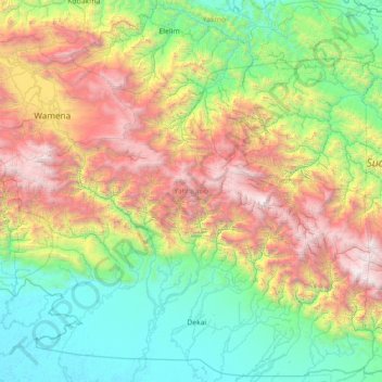
Name: Yahukimo topographic map, elevation, terrain.
Location: Yahukimo, Papua, Indonesia (-5.16890 138.83354 -3.61172 140.25299)
Average elevation: 1,247 m
Minimum elevation: 0 m
Maximum elevation: 4,721 m
Other topographic maps
Click on a map to view its topography, its elevation and its terrain.
Undundi-Wandandi
Undundi-Wandandi, Paniai, Papua, Indonesia
Average elevation: 3,185 m
Maoke Mountains
Maoke Mountains, Trikora District, Jayawijaya, Papua, Indonesia
Average elevation: 2,858 m
East Northwall Firn
East Northwall Firn, Mimika, Papua, Indonesia
Average elevation: 4,388 m