
Thank you for supporting this site ❤️
Make a donation
Make a donation
Maboloka topographic map
Click on the map to display elevation.
Thank you for supporting this site ❤️
Make a donation
Make a donation
About this map
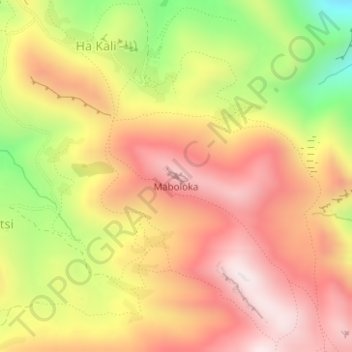
Name: Maboloka topographic map, elevation, terrain.
Location: Maboloka, Ha Kali, Qacha's Nek District, Lesotho (-30.09024 28.34768 -30.09014 28.34778)
Average elevation: 2,392 m
Minimum elevation: 2,005 m
Maximum elevation: 2,663 m
Thank you for supporting this site ❤️
Make a donation
Make a donation