
白云山 topographic map
Interactive map
Click on the map to display elevation.
About this map
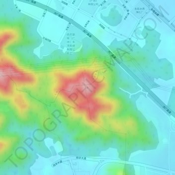
Name: 白云山 topographic map, elevation, terrain.
Location: 白云山, Guangzhou City, Guangdong Province, 120000, China (23.17302 113.56513 23.17312 113.56523)
Average elevation: 79 m
Minimum elevation: 15 m
Maximum elevation: 251 m
Other topographic maps
Click on a map to view its topography, its elevation and its terrain.
Huangpu District
China > Guangdong Province > Guangzhou City
The district is pioneering in the low-altitude economy, which includes the development of aerial innovations. Notably, EHang Holdings, based in Huangpu, received the first certification for manned eVTOL (electric vertical take-off and landing) aircraft, positioning the district at the forefront of the urban…
Average elevation: 45 m