
Make a donation
Laše topographic map
Click on the map to display elevation.
Make a donation
About this map
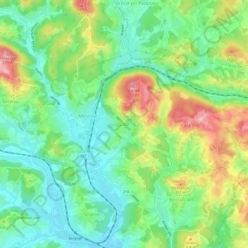
Name: Laše topographic map, elevation, terrain.
Location: Laše, Šmarje pri Jelšah, 3241, Slovenia (46.21495 15.55163 46.25495 15.59163)
Average elevation: 262 m
Minimum elevation: 208 m
Maximum elevation: 356 m
Make a donation
Other topographic maps
Click on a map to view its topography, its elevation and its terrain.
Triglav National Park
Systematic surveys of plants, especially of ethnobotanically useful species, in Triglav National Park have been carried out by Chandra Prakash Kala and Petra Ratajc covering various microhabitats, elevations, aspects, and terrain types. The park has over fifty-nine species of ethnobotanical values, of these 37…
Average elevation: 1,063 m
Mirna Peč
The valley, with an elevation of about 260 m, contains a shallow aquifer with a limited groundwater supply. Igmanca Creek, also known as Poljane Creek (Slovene: Poljanski potok), surfaces and disappears underground twice along the valley. Karst features such as small swallow holes, estavelles, and, to a lesser…
Average elevation: 314 m
Make a donation
Make a donation
Make a donation
Make a donation
Soča
An Alpine river in character, its source lies in the Trenta Valley in the Julian Alps in northwestern Slovenia, at an elevation of 876 metres (2,874 ft). The river runs past the towns of Bovec, Kobarid, Tolmin, Kanal ob Soči, Nova Gorica (where it is crossed by the Solkan Bridge), and Gorizia, entering the…
Average elevation: 562 m
Make a donation
Karst Plateau
It lies between the Vipava Valley, the low hills surrounding the valley, the westernmost part of the Brkini Hills, northern Istria, and the Gulf of Trieste. The western edge of the plateau also marks the traditional ethnic border between Italians and Slovenes. The region gave its name to karst topography. For…
Average elevation: 285 m
Make a donation
Make a donation
Make a donation
Make a donation
Make a donation
Make a donation
Make a donation
Make a donation
Make a donation
Make a donation
Make a donation
Make a donation
Make a donation
Make a donation
Make a donation
Piran / Pirano
The Municipality of Piran borders Croatia to the south and the municipalities of Izola and Koper to the east, and it faces Italy across the Gulf of Trieste and the Adriatic Sea. The highest point, Baretovec pri Padni, has an elevation of 289 meters (948 ft).
Average elevation: 34 m
Make a donation
Make a donation
Make a donation
Make a donation
Make a donation