
Shanghai topographic map
Click on the map to display elevation.
Shanghai
The golden age of Shanghai began with its elevation to municipality after it was separated from Jiangsu on 7 July 1927. This new Chinese municipality covered an area of 494.69 km2 (191.0 sq mi), including the modern-day districts of Baoshan, Yangpu, Zhabei, Nanshi, and Pudong, but excluded the foreign concessions territories. Headed by a Chinese mayor and municipal council, the new city government's first task—the Greater Shanghai Plan—was to create a new city center in Jiangwan town of Yangpu district, outside the boundaries of the foreign concessions. The plan included a public museum, library, sports stadium, and city hall, which were partially constructed before being interrupted by the Japanese invasion. In the 1920s, shidaiqu became a new form of entertainment and was popularised in Shanghai.
About this map
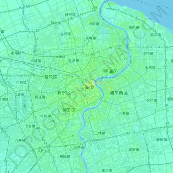
Name: Shanghai topographic map, elevation, terrain.
Location: Shanghai, Huangpu District, 200001, China (31.07234 121.30910 31.39234 121.62910)
Average elevation: 5 m
Minimum elevation: -6 m
Maximum elevation: 40 m
Other topographic maps
Click on a map to view its topography, its elevation and its terrain.
Kunming
Kunming is at an altitude of 1,900 metres (6,234 feet) above sea level and a latitude just north of the Tropic of Cancer, and is situated in the middle of the Yunnan–Guizhou Plateau. Kunming is the fourth most populous city in Western China, after Chongqing, Chengdu, and Xi'an, and the third most populous…
Average elevation: 1,996 m
Jingzhou
Jingzhou occupies an area of 14,067 square kilometres (5,431 sq mi) with a topography rising from east to west. It is covered by a dense network of waterways, as well as lakes, and is located in the middle reaches of the Yangtze River on the Jianghan Plain. Downstream to its east lies Wuhan, the provincial…
Average elevation: 156 m
Huangshi
Huangshi is located in southeastern Hubei province, primarily along the southwestern bank of one of the major bends in the Yangtze River. It is located 100 kilometers (62 mi) southeast of Wuhan, and borders Jiangxi province to the south. Its area was reported by the local government as 4,583 square kilometers…
Average elevation: 123 m
Yunnan
Yunnan is situated in a mountainous area, with high elevations in the northwest and low elevations in the southeast. Most of the population lives in the eastern part of the province. In the west, the altitude can vary from the mountain peaks to river valleys by as much as 3,000 m (9,800 ft). Yunnan is rich in…
Average elevation: 1,713 m
Sichuan
Due to great differences in terrain, the climate of the province is highly variable. In general, it has strong monsoonal influences, with rainfall heavily concentrated in the summer. Under the Köppen climate classification, the Sichuan Basin (including Chengdu) in the eastern half of the province experiences…
Average elevation: 2,522 m
Jiangxi
The southern half of Jiangxi is hilly and mountainous, with ranges and valleys interspersed; notable mountains and mountain ranges include Mountain Lu, the Jinggang Mountains and Mount Sanqing. The northern half is comparatively lower in altitude. The Gan River flows through the province.
Average elevation: 327 m
Qingyuan City
Qingyuan's administrative area ranges in latitude from 23° 26' 56" to 25° 11' 40" N, and in longitude from 111° 55' 17" to 113° 55' 34" E; its urban area is located just north of the Tropic of Cancer, about 60 km (37 mi) from the urban area of Guangzhou and 200 km (120 mi) from both Hong Kong and Macau.…
Average elevation: 349 m
Guilin
Guilin (Standard Zhuang: Gveilinz), formerly romanized as Kweilin, is a prefecture-level city in the northeast of China's Guangxi Zhuang Autonomous Region. It is situated on the west bank of the Li River and borders Hunan to the north. Its name means "forest of sweet osmanthus", owing to the large number of…
Average elevation: 472 m
Shiyan
The far northern and southern reaches of Shiyan are the highest in elevation, while the geographic center of the city has a relatively low elevation. The highest point in Shiyan is Congping in Zhuxi County, at 2,740.2 metres (8,990 ft) above sea level, while the lowest point, Panjiayan in Danjiangkou, is 87…
Average elevation: 782 m
Huai'an
Huai'an lies on the Huai River in the alluvial Jianghuai Plain. The area is very flat with only a few notable hills in Xuyi County. The highest altitude in the municipality is 200 meters (660 ft). The area is notable for its large number of lakes, rivers, and canals. The Grand Canal connects with the Huai in…
Average elevation: 13 m
Tengzhou City
Tengzhou is Located on the Huanghuai Plain, it borders the Taiyi Mountain to the east and Weishan Lake to the west, and has a minimum elevation of 33.5 metres (110 ft), and a maximum elevation of 596.6 metres (1,957 ft).
Average elevation: 88 m
Bazhong
Bazhong is located at the southern end of the Daba Mountains, and borders Shaanxi province to the north, Dazhou to the east, Nanchong to the south, and Guangyuan to the west. Its area is 12,301 square kilometres (4,749 sq mi), which is mountainous with elevations up to 208.3 to 2,507 metres (683 to 8,225 ft)…
Average elevation: 852 m
Yinchuan City
Yinchuan lies in the middle of the Yinchuan Plain. It is sheltered from the deserts of Mongolia by the high ranges of the Helan Mountains to its west. The Yellow River runs through Yinchuan from southwest to northeast. The average elevation of Yinchuan is 1,100 meters (about 3,608 feet). The urban center of…
Average elevation: 1,340 m
Xiong'an New Area
The area is located in the plain to the east of Taihang Mountain. The terrain gradually decreases from northwest to southeast. The ground elevation is mostly 5 to 26 meters, and the ground slope is less than 2‰.
Average elevation: 13 m
Changchun City
Changchun lies in the middle portion of the Northeast China Plain. Its municipality area is located at latitude 43° 05′−45° 15′ N and longitude 124° 18′−127° 02' E. The total area of Changchun municipality is 20,571 km2 (7,943 sq mi), including metro areas of 2,583 square kilometres (997 sq mi),…
Average elevation: 215 m
Linfen
Within its borders Linfen City has a variety of topographical features. It is characterised as having a "U" shape, with its mountains, covering 29.2% of the prefectural area, on all four cardinal directions, a basin, the Linfen Basin (临汾盆地), covering 19.4%, in the middle, and intervening hills,…
Average elevation: 988 m
Jiangmen
A significant amount of historical heritage survives from the period of mass emigration prior to World War II. The most significant are the fortified multi-story towers found mainly in Kaiping. These are known as "Gold Mountain Towers" or diaolou. A number of natural hotspring resorts has been developed…
Average elevation: 31 m
Chaozhou
The Chaozhou territory is mountainous. In particular, the nearby Phoenix Mountain's peak is located 1,497 meters (4,911 ft) above sea level. The main nearby rivers are the Huanggang River and the Han River. The Han River flows from west to southeast, and ramps through downtown Chaozhou; the Huanggang river…
Average elevation: 209 m