
Thank you for supporting this site ❤️
Make a donation
Make a donation
Middelburg topographic map
Click on the map to display elevation.
Thank you for supporting this site ❤️
Make a donation
Make a donation
About this map
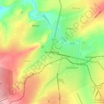
Name: Middelburg topographic map, elevation, terrain.
Average elevation: 1,493 m
Minimum elevation: 1,408 m
Maximum elevation: 1,585 m
Thank you for supporting this site ❤️
Make a donation
Make a donation
Other topographic maps
Click on a map to view its topography, its elevation and its terrain.
Loskop Dam
South Africa > Mpumalanga > Nkangala > Steve Tshwete Local Municipality
Average elevation: 1,211 m
Middelburg Dam
South Africa > Mpumalanga > Nkangala > Steve Tshwete Local Municipality
Average elevation: 1,543 m
Steve Tshwete Ward 11
South Africa > Mpumalanga > Nkangala > Steve Tshwete Local Municipality
Average elevation: 1,520 m
Kranspoort Dam
South Africa > Mpumalanga > Nkangala > Steve Tshwete Local Municipality
Average elevation: 1,095 m
Thank you for supporting this site ❤️
Make a donation
Make a donation
Steve Tshwete Ward 11
South Africa > Mpumalanga > Nkangala > Steve Tshwete Local Municipality
Average elevation: 1,520 m