
Okinsky Rayon topographic map
Interactive map
Click on the map to display elevation.
About this map
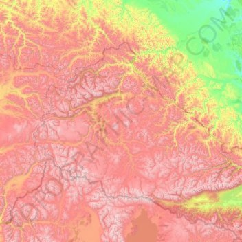
Name: Okinsky Rayon topographic map, elevation, terrain.
Location: Okinsky Rayon, Buryatia, Far Eastern Federal District, Russia (51.71859 98.62992 53.37559 102.82745)
Average elevation: 1,651 m
Minimum elevation: 461 m
Maximum elevation: 3,386 m
Other topographic maps
Click on a map to view its topography, its elevation and its terrain.
Нарын
Russia > Buryatia > Верхнеилькинское сельское поселение
Нарын, Верхнеилькинское сельское поселение, Zaigrayevsky Rayon, Buryatia, Far Eastern Federal District, Russia
Average elevation: 745 m
Bichursky Rayon
Bichursky Rayon, Buryatia, Far Eastern Federal District, Russia
Average elevation: 872 m