
Thank you for supporting this site ❤️
Make a donation
Make a donation
Imbabura topographic map
Click on the map to display elevation.
Thank you for supporting this site ❤️
Make a donation
Make a donation
Imbabura
The summit of Cotacachi Volcano at an elevation of 4,944 metres (16,220 ft) is 15 kilometres (9.3 mi) north-east of the town of Cotacachi. The volcano is located in the large Cotacachi Cayapas Ecological Reserve.
Thank you for supporting this site ❤️
Make a donation
Make a donation
About this map
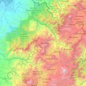
Name: Imbabura topographic map, elevation, terrain.
Location: Imbabura, Ecuador (0.12291 -79.27576 0.87661 -77.81039)
Average elevation: 1,923 m
Minimum elevation: -4 m
Maximum elevation: 5,669 m
Thank you for supporting this site ❤️
Make a donation
Make a donation
Other topographic maps
Click on a map to view its topography, its elevation and its terrain.