
Make a donation
Chongqing topographic map
Click on the map to display elevation.
Make a donation
Chongqing
The central urban area of Chongqing, or Chongqing proper, is a city of unique features. Built on mountains and partially surrounded by the Yangtze and Jialing rivers, it is known as a "mountain city" and a "city on rivers". The night scene of the city is very illuminated, with millions of lights and their reflection on the rivers. With its special topographical features, Chongqing has the unique scenery of mountains, rivers, forests, springs, waterfalls, gorges, and caves. Li Bai, a famous poet of the Tang dynasty, was inspired by the natural scenery and wrote this epigram.
Make a donation
About this map
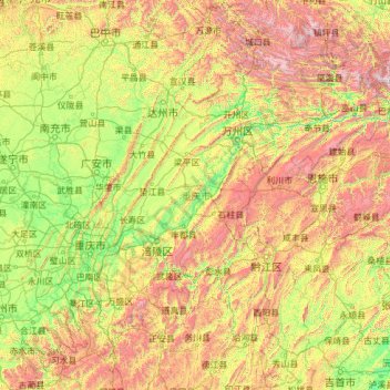
Name: Chongqing topographic map, elevation, terrain.
Location: Chongqing, China (28.16174 105.28683 32.20366 110.19444)
Average elevation: 754 m
Minimum elevation: 72 m
Maximum elevation: 3,007 m
Make a donation
Other topographic maps
Click on a map to view its topography, its elevation and its terrain.
Jade Dragon Snow Mountain
China > Yunnan > Lijiang City
The view of the massif from the gardens at the Black Dragon Pool (Heilong Tan) in Lijiang is noted as one of China's finest views. The mountain is part of Yulong Snow Mountain National Scenic Area and National Geological Park, an AAAAA-classified scenic area. The Park operates a tourist cable car that climbs…
Average elevation: 4,829 m
Shanghai
The golden age of Shanghai began with its elevation to municipality after it was separated from Jiangsu on 7 July 1927. This new Chinese municipality covered an area of 494.69 km2 (191.0 sq mi), including the modern-day districts of Baoshan, Yangpu, Zhabei, Nanshi, and Pudong, but excluded the foreign…
Average elevation: 5 m
Make a donation
Make a donation
Make a donation