
Campo Grande topographic map
Interactive map
Click on the map to display elevation.
About this map
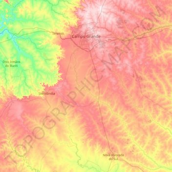
Name: Campo Grande topographic map, elevation, terrain.
Average elevation: 435 m
Minimum elevation: 174 m
Maximum elevation: 742 m
Campo Grande has a tropical savanna climate (Köppen: Aw), just slightly drier than a tropical monsoon climate, with a mild appearance of cold air masses on the southern edge of the tropics. It has semi-humid, hot summers, and notably seasonal, with a dry winter season from June through September, but without major irregularities in the precipitation. Its altitude a few hundred meters higher than in the surrounding swamps and its location in the interior of South America, gives a much more extreme climate than several Brazilian cities, although still moderate. In addition, the flood is one of the problems seen in the city, the result of intense rains that occur in a short period. Annual rainfall averages 1,465 millimetres (57.7 in). January is the warmest and rainiest month, with mean highs of 29 °C (84.2 °F) and lows of 20 °C (68.0 °F).