
Dindori topographic map
Click on the map to display elevation.
About this map
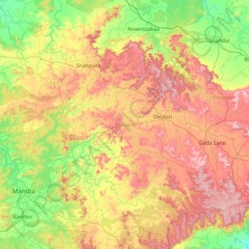
Name: Dindori topographic map, elevation, terrain.
Location: Dindori, Madhya Pradesh, India (22.43971 80.47772 23.37464 81.73882)
Average elevation: 631 m
Minimum elevation: 357 m
Maximum elevation: 1,108 m
Other topographic maps
Click on a map to view its topography, its elevation and its terrain.
Bhopal
India > Madhya Pradesh > Huzur Tahsil
Bhopal has an average elevation of 500 metres (1401 ft) and is located in the central part of India, just north of the upper limit of the Vindhya mountain ranges. Located on the Malwa plateau, it is higher than the north Indian plains and the land rises towards the Vindhya Range to the south. The city has…
Average elevation: 498 m