
Make a donation
Kanpur topographic map
Click on the map to display elevation.
Make a donation
Kanpur
Situated in the flat Indo-Gangetic Plains, Kanpur has an average elevation of 318 m above sea level. The Ganges flows by the city and several ghats are located on its banks, notably the Sati Chaura Ghat and Sarsaiya Ghat. The Brahmavart Ghat located at Bithoor (25 km northwards) is another ghat of religious importance.
Make a donation
About this map
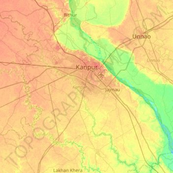
Name: Kanpur topographic map, elevation, terrain.
Location: Kanpur, Kanpur Nagar, Uttar Pradesh, India (26.17384 80.11959 26.64013 80.59143)
Average elevation: 124 m
Minimum elevation: 104 m
Maximum elevation: 137 m
Make a donation
Other topographic maps
Click on a map to view its topography, its elevation and its terrain.
Varanasi
India > Uttar Pradesh > Sadar
Varanasi is located at an elevation of 80.71 metres (264.8 ft) in the centre of the Ganges valley of North India, in the Eastern part of the state of Uttar Pradesh, along the left crescent-shaped bank of the Ganges, averaging between 15 metres (50 ft) and 21 metres (70 ft) above the river. The city is the…
Average elevation: 77 m
Prayagraj
India > Uttar Pradesh > Prayagraj
Prayagraj's elevation is over 90 m (295 ft) above sea level. The old part of the city, at the south of Prayagraj Junction railway station, consists of neighbourhoods like Chowk, Johnstongunj, Dariyabad, Khuldabad and many more. In the north of the Railway Station, the new city consists of neighbourhoods like…
Average elevation: 91 m
Lucknow
India > Uttar Pradesh > Lucknow
Lucknow stands at an elevation of approximately 123 metres (404 ft) above sea level. The city had an area of 402 km2 (155 square miles) until December 2019, when 88 villages were added to the municipal limits and the area increased to 631 km2 (244 square miles).
Average elevation: 120 m