
Kgetleng River Local Municipality topographic map
Click on the map to display elevation.
About this map
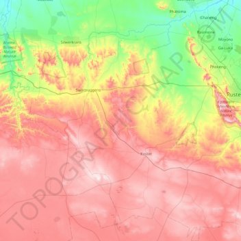
Name: Kgetleng River Local Municipality topographic map, elevation, terrain.
Average elevation: 1,367 m
Minimum elevation: 1,015 m
Maximum elevation: 1,724 m
Other topographic maps
Click on a map to view its topography, its elevation and its terrain.
Sun City
South Africa > North West > Bojanala Platinum District Municipality > Moses Kotane Local Municipality > Sun City
Average elevation: 1,158 m
Buffelspoort Dam
South Africa > North West > Bojanala Platinum District Municipality > Rustenburg Local Municipality
Average elevation: 1,311 m
Melodie
South Africa > North West > Bojanala Platinum District Municipality > Madibeng Local Municipality
Average elevation: 1,240 m
Makolokwe
South Africa > North West > Bojanala Platinum District Municipality > Rustenburg Local Municipality > Makolokwe
Average elevation: 1,139 m
Dikhololo
South Africa > North West > Bojanala Platinum District Municipality > Madibeng Local Municipality
Average elevation: 1,180 m
Wonderkop
South Africa > North West > Bojanala Platinum District Municipality > Madibeng Local Municipality
Average elevation: 1,123 m
Modderspruit
South Africa > North West > Bojanala Platinum District Municipality > Madibeng Local Municipality
Average elevation: 1,215 m
Nonceba
South Africa > North West > Bojanala Platinum District Municipality > Moses Kotane Local Municipality
Average elevation: 1,062 m
Silwerkrans
South Africa > North West > Bojanala Platinum District Municipality > Moses Kotane Local Municipality
Average elevation: 1,212 m
Bapong
South Africa > North West > Bojanala Platinum District Municipality > Madibeng Local Municipality
Average elevation: 1,196 m
Ifafi
South Africa > North West > Bojanala Platinum District Municipality > Madibeng Local Municipality
Average elevation: 1,230 m
Sesobe
South Africa > North West > Bojanala Platinum District Municipality > Moses Kotane Local Municipality
Average elevation: 984 m
Sandfontein
South Africa > North West > Bojanala Platinum District Municipality > Moses Kotane Local Municipality
Average elevation: 1,149 m
Magalies
South Africa > North West > Bojanala Platinum District Municipality > Madibeng Local Municipality
Average elevation: 1,297 m
Tlapa
South Africa > North West > Bojanala Platinum District Municipality > Rustenburg Local Municipality
Average elevation: 1,146 m
Bethanie
South Africa > North West > Bojanala Platinum District Municipality > Rustenburg Local Municipality
Average elevation: 1,083 m