
Thank you for supporting this site ❤️
Make a donation
Make a donation
Gandipet mandal topographic map
Click on the map to display elevation.
Thank you for supporting this site ❤️
Make a donation
Make a donation
About this map
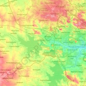
Name: Gandipet mandal topographic map, elevation, terrain.
Location: Gandipet mandal, Ranga Reddy, Telangana, India (17.32791 78.22810 17.43418 78.42037)
Average elevation: 559 m
Minimum elevation: 494 m
Maximum elevation: 631 m
Thank you for supporting this site ❤️
Make a donation
Make a donation
Other topographic maps
Click on a map to view its topography, its elevation and its terrain.
Warangal
India > Telangana > Warangal mandal
Warangal is located at 18°00′N 79°35′E / 18.0°N 79.58°E / 18.0; 79.58. It has an average elevation of 266 metres (873 feet). It is settled in the eastern part of Deccan Plateau made up of granite rocks and hill formations which left the region barren making the cultivation dependent on…
Average elevation: 268 m