
Thank you for supporting this site ❤️
Make a donation
Make a donation
Sriperumbudur topographic map
Click on the map to display elevation.
Thank you for supporting this site ❤️
Make a donation
Make a donation
About this map
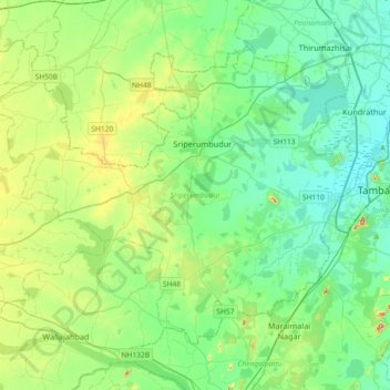
Name: Sriperumbudur topographic map, elevation, terrain.
Location: Sriperumbudur, Kanchipuram District, Tamil Nadu, India (12.78445 79.74086 13.05563 80.10487)
Average elevation: 48 m
Minimum elevation: 11 m
Maximum elevation: 159 m
Thank you for supporting this site ❤️
Make a donation
Make a donation
Other topographic maps
Click on a map to view its topography, its elevation and its terrain.
Edappadi
India > Tamil Nadu > Edappadi
Edappadi has an average elevation of 288 m (945 ft). It is situated at the basin of a hill called 'Soorieya malai' (Mountain of Sun). The mountain does not have any plants due to its rocky and unusual properties. Research done by Periyar University Geologist shows it consists of rare radioactive minerals.…
Average elevation: 224 m