
Cotswold District topographic map
Interactive map
Click on the map to display elevation.
About this map
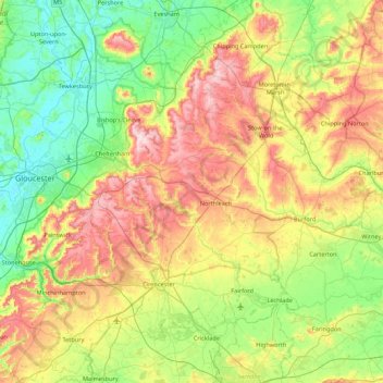
Name: Cotswold District topographic map, elevation, terrain.
Location: Cotswold District, Gloucestershire, England, United Kingdom (51.57753 -2.32361 52.11258 -1.61520)
Average elevation: 118 m
Minimum elevation: 6 m
Maximum elevation: 328 m
Other topographic maps
Click on a map to view its topography, its elevation and its terrain.
Gloucester
United Kingdom > England > Gloucestershire
Gloucester, Gloucestershire, England, United Kingdom
Average elevation: 36 m
Bishop's Cleeve
United Kingdom > England > Gloucestershire > Woodmancote
Bishop's Cleeve, Woodmancote, Tewkesbury, Gloucestershire, England, United Kingdom
Average elevation: 84 m