
Thank you for supporting this site ❤️
Make a donation
Make a donation
Amherst topographic map
Click on the map to display elevation.
Thank you for supporting this site ❤️
Make a donation
Make a donation
About this map
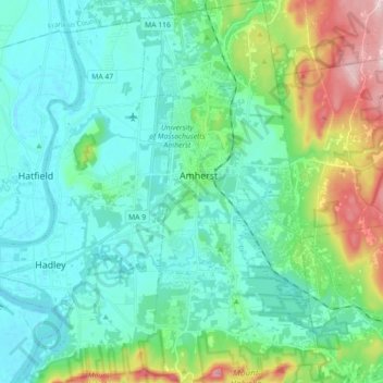
Name: Amherst topographic map, elevation, terrain.
Location: Amherst, Hampshire County, Massachusetts, United States (42.30146 -72.54678 42.43382 -72.46419)
Average elevation: 100 m
Minimum elevation: 27 m
Maximum elevation: 361 m
Thank you for supporting this site ❤️
Make a donation
Make a donation
Other topographic maps
Click on a map to view its topography, its elevation and its terrain.
Thank you for supporting this site ❤️
Make a donation
Make a donation
South Hadley Falls
United States > Massachusetts > Hampshire County > South Hadley
Average elevation: 50 m
Thank you for supporting this site ❤️
Make a donation
Make a donation
Mill River Recreation Area
United States > Massachusetts > Hampshire County > Amherst > North Amherst
Average elevation: 66 m
Wildwood Conservation Area
United States > Massachusetts > Hampshire County > Amherst
Average elevation: 89 m
Thank you for supporting this site ❤️
Make a donation
Make a donation
Thank you for supporting this site ❤️
Make a donation
Make a donation
Worthington Corners
United States > Massachusetts > Hampshire County > Worthington
Average elevation: 450 m
Thank you for supporting this site ❤️
Make a donation
Make a donation