
Porterville topographic map
Interactive map
Click on the map to display elevation.
About this map
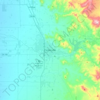
Name: Porterville topographic map, elevation, terrain.
Average elevation: 222 m
Minimum elevation: 95 m
Maximum elevation: 1,003 m
Porterville, lying along the foothills of the Sierras at an elevation of 455 feet (139 m), is located on State Highway 65, 165 miles (266 km) north of Los Angeles, and 171 miles (275 km) east of the Pacific Coast. The city has a strategic central location to major markets and a ready access to major transportation routes.