
Thank you for supporting this site ❤️
Make a donation
Make a donation
Hövelhof topographic map
Click on the map to display elevation.
Thank you for supporting this site ❤️
Make a donation
Make a donation
About this map
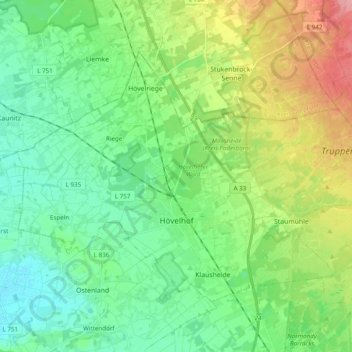
Name: Hövelhof topographic map, elevation, terrain.
Average elevation: 117 m
Minimum elevation: 83 m
Maximum elevation: 195 m
Thank you for supporting this site ❤️
Make a donation
Make a donation
Other topographic maps
Click on a map to view its topography, its elevation and its terrain.
Bad Lippspringe
Germany > North Rhine-Westphalia > Kreis Paderborn > Bad Lippspringe > Bad Lippspringe
Average elevation: 162 m