
Thank you for supporting this site ❤️
Make a donation
Make a donation
Valkenburg topographic map
Click on the map to display elevation.
Thank you for supporting this site ❤️
Make a donation
Make a donation
About this map
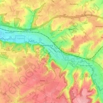
Name: Valkenburg topographic map, elevation, terrain.
Location: Valkenburg, Valkenburg aan de Geul, Limburg, Netherlands (50.82955 5.77208 50.89223 5.87007)
Average elevation: 123 m
Minimum elevation: 56 m
Maximum elevation: 174 m
Thank you for supporting this site ❤️
Make a donation
Make a donation
Other topographic maps
Click on a map to view its topography, its elevation and its terrain.