
Agra topographic map
Click on the map to display elevation.
Agra
The region around Agra consists almost entirely of a level plain, with hills in the extreme southwest. The rivers in the region include Yamuna and Chambal. The region is also watered by the Agra Canal. Millet, barley, wheat and cotton are among the crops grown in the surrounding countryside. Both Rabi and Kharif crops are cultivated. The deserted city of Fatehpur Sikri is about 40 km southwest of Agra. The sandstone hills near Fatehpur Sikri and on the south-eastern borders of the district are offshoots from the Vindhya range of Central India. Agra is about 210 km away from the National capital of New Delhi (via Yamuna Expressway), about 336 km from state capital Lucknow (via Agra-Lucknow Expressway), and about 227 km from Kanpur (via Agra-Lucknow Expressway). The city has an average elevation of 170 metres above sea level.
About this map
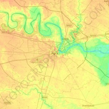
Name: Agra topographic map, elevation, terrain.
Location: Agra, Uttar Pradesh, India (27.04546 77.85102 27.29632 78.22076)
Average elevation: 166 m
Minimum elevation: 143 m
Maximum elevation: 183 m
Other topographic maps
Click on a map to view its topography, its elevation and its terrain.
Varanasi
India > Uttar Pradesh > Sadar
Varanasi is located at an elevation of 80.71 metres (264.8 ft) in the centre of the Ganges valley of North India, in the Eastern part of the state of Uttar Pradesh, along the left crescent-shaped bank of the Ganges, averaging between 15 metres (50 ft) and 21 metres (70 ft) above the river. The city is the…
Average elevation: 77 m
Prayagraj
India > Uttar Pradesh > Prayagraj
Prayagraj's elevation is over 90 m (295 ft) above sea level. The old part of the city, at the south of Prayagraj Junction railway station, consists of neighbourhoods like Chowk, Johnstongunj, Dariyabad, Khuldabad and many more. In the north of the Railway Station, the new city consists of neighbourhoods like…
Average elevation: 91 m
Lucknow
India > Uttar Pradesh > Lucknow
Lucknow stands at an elevation of approximately 123 metres (404 ft) above sea level. The city had an area of 402 km2 (155 square miles) until December 2019, when 88 villages were added to the municipal limits and the area increased to 631 km2 (244 square miles).
Average elevation: 120 m