
Lübeck topographic map
Interactive map
Click on the map to display elevation.
About this map
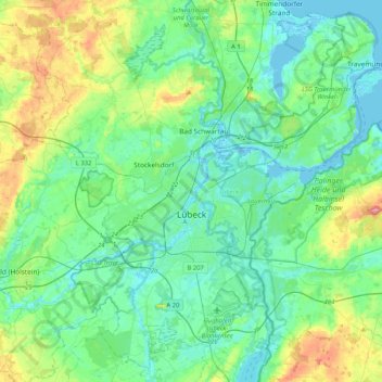
Name: Lübeck topographic map, elevation, terrain.
Location: Lübeck, Schleswig-Holstein, Germany (53.76801 10.55404 53.99389 10.96863)
Average elevation: 25 m
Minimum elevation: -4 m
Maximum elevation: 109 m
Other topographic maps
Click on a map to view its topography, its elevation and its terrain.
Simonsberg
Germany > Schleswig-Holstein > Simonsberg
Simonsberg, Nordsee-Treene, Northern Friesland, Schleswig-Holstein, Germany
Average elevation: 0 m
Mitteltritt
Germany > Schleswig-Holstein > Hallig Hooge > Mitteltritt
Mitteltritt, Hallig Hooge, Pellworm, Northern Friesland, Schleswig-Holstein, 25859, Germany
Average elevation: 0 m
Flensburg
Germany > Schleswig-Holstein > Flensburg
Flensburg, Schleswig-Holstein, 24937, Germany
Average elevation: 39 m
Vaale
Germany > Schleswig-Holstein > Kreis Steinburg
Vaale, Amt Schenefeld, Kreis Steinburg, Schleswig-Holstein, 25594, Germany
Average elevation: 13 m
Güster
Germany > Schleswig-Holstein > Güster
Güster, Büchen, Herzogtum Lauenburg, Schleswig-Holstein, Germany
Average elevation: 22 m
Schaalsee
Germany > Schleswig-Holstein > Seedorf
Schaalsee, Bokop, Seedorf, Lauenburgische Seen, Herzogtum Lauenburg, Schleswig-Holstein, 23883, Germany
Average elevation: 43 m