
Thank you for supporting this site ❤️
Make a donation
Make a donation
Cologne topographic map
Click on the map to display elevation.
Thank you for supporting this site ❤️
Make a donation
Make a donation
About this map
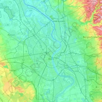
Name: Cologne topographic map, elevation, terrain.
Location: Cologne, North Rhine-Westphalia, Germany (50.83044 6.77253 51.08497 7.16203)
Average elevation: 69 m
Minimum elevation: 32 m
Maximum elevation: 228 m
Thank you for supporting this site ❤️
Make a donation
Make a donation
Other topographic maps
Click on a map to view its topography, its elevation and its terrain.