
Oxford topographic map
Interactive map
Click on the map to display elevation.
About this map
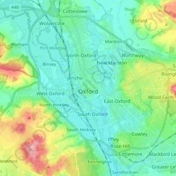
Name: Oxford topographic map, elevation, terrain.
Location: Oxford, Oxfordshire, England, United Kingdom (51.71098 -1.30425 51.79627 -1.17581)
Average elevation: 81 m
Minimum elevation: 50 m
Maximum elevation: 170 m
Other topographic maps
Click on a map to view its topography, its elevation and its terrain.
Highmoor
United Kingdom > England > Oxfordshire > South Oxfordshire
Highmoor, South Oxfordshire, Oxfordshire, England, United Kingdom
Average elevation: 138 m