
Thank you for supporting this site ❤️
Make a donation
Make a donation
Volta Region topographic map
Click on the map to display elevation.
Thank you for supporting this site ❤️
Make a donation
Make a donation
About this map
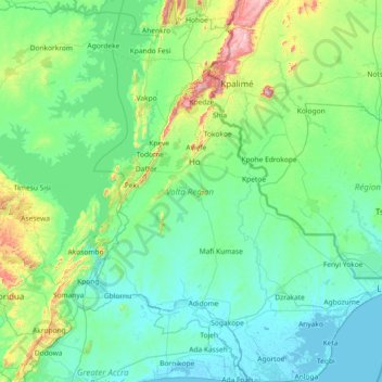
Name: Volta Region topographic map, elevation, terrain.
Location: Volta Region, Ghana (5.77100 0.08148 7.22663 1.19963)
Average elevation: 121 m
Minimum elevation: -8 m
Maximum elevation: 978 m
Thank you for supporting this site ❤️
Make a donation
Make a donation
Other topographic maps
Click on a map to view its topography, its elevation and its terrain.
Sekondi-Takoradi
Ghana > Western Region > Sekondi Takoradi Metropolitan District
Average elevation: 19 m
Thank you for supporting this site ❤️
Make a donation
Make a donation
Thank you for supporting this site ❤️
Make a donation
Make a donation