
Thank you for supporting this site ❤️
Make a donation
Make a donation
Ganyesa topographic map
Click on the map to display elevation.
Thank you for supporting this site ❤️
Make a donation
Make a donation
About this map
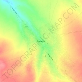
Name: Ganyesa topographic map, elevation, terrain.
Average elevation: 1,291 m
Minimum elevation: 1,249 m
Maximum elevation: 1,324 m
Thank you for supporting this site ❤️
Make a donation
Make a donation
Other topographic maps
Click on a map to view its topography, its elevation and its terrain.
Kagisano-Molopo Local Municipality
South Africa > North West > Dr Ruth Segomotsi Mompati District Municipality > Kagisano-Molopo Local Municipality
Average elevation: 1,159 m