
Southern Alps topographic map
Interactive map
Click on the map to display elevation.
About this map
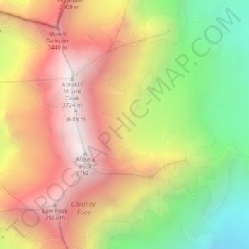
Name: Southern Alps topographic map, elevation, terrain.
Location: Southern Alps, Mackenzie District, Canterbury, New Zealand (-43.60005 170.14995 -43.59995 170.15005)
Average elevation: 2,832 m
Minimum elevation: 1,848 m
Maximum elevation: 3,709 m
Other topographic maps
Click on a map to view its topography, its elevation and its terrain.
Earthquakes
New Zealand > Canterbury > Waitaki District
Earthquakes, Waitaki District, Canterbury, New Zealand
Average elevation: 237 m
Selwyn District
Selwyn District, Canterbury, New Zealand
Average elevation: 679 m
Halswell-Hornby-Riccarton Community
New Zealand > Canterbury > Christchurch City
Halswell-Hornby-Riccarton Community, Christchurch City, Canterbury, New Zealand
Average elevation: 49 m
Lincoln
New Zealand > Canterbury > Selwyn District > Lincoln
Lincoln, Selwyn District, Canterbury, 7608, New Zealand
Average elevation: 15 m
Lyttelton
New Zealand > Canterbury > Lyttelton
Lyttelton, Christchurch City, Canterbury, 8082, New Zealand
Average elevation: 99 m
Mount Wilson
Mount Wilson, Selwyn District, Canterbury, New Zealand
Average elevation: 1,569 m
Lyttelton
New Zealand > Canterbury > Lyttelton
Lyttelton, Christchurch City, Canterbury, 8082, New Zealand
Average elevation: 105 m
Dennistoun Glacier
Dennistoun Glacier, Mackenzie District, Canterbury, New Zealand
Average elevation: 2,026 m
Ball Glacier
Ball Glacier, Caroline hut to ball hut, Mackenzie District, Canterbury, New Zealand
Average elevation: 1,324 m
Mount Hutt
Mount Hutt, Ashburton District, Canterbury, New Zealand
Average elevation: 1,732 m
Maud Glacier
Maud Glacier, Mackenzie District, Canterbury, New Zealand
Average elevation: 1,711 m
Mount Dampier
Mount Dampier, Mackenzie District, Canterbury, New Zealand
Average elevation: 2,847 m
Mount Cook
Mount Cook, Mackenzie District, Canterbury, New Zealand
Average elevation: 2,920 m
Anna Glacier
Anna Glacier, Mackenzie District, Canterbury, New Zealand
Average elevation: 2,446 m
Mueller Glacier
New Zealand > Canterbury > Mount Cook Village
Mueller Glacier, Mueller Hut Route, Mount Cook Village, Mackenzie District, Canterbury, 7946, New Zealand
Average elevation: 1,616 m
Te Hīwai / Murchison Glacier
Te Hīwai / Murchison Glacier, Mackenzie District, Canterbury, New Zealand
Average elevation: 1,875 m
Cascade Glacier
Cascade Glacier, Mackenzie District, Canterbury, New Zealand
Average elevation: 2,106 m
Christchurch City
Christchurch City, Canterbury, New Zealand
Average elevation: 74 m
Godley Glacier
Godley Glacier, Mackenzie District, Canterbury, New Zealand
Average elevation: 1,579 m