
Eerste River topographic map
Interactive map
Click on the map to display elevation.
About this map
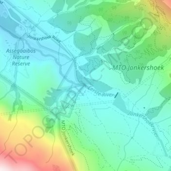
Name: Eerste River topographic map, elevation, terrain.
Average elevation: 372 m
Minimum elevation: 206 m
Maximum elevation: 912 m
Other topographic maps
Click on a map to view its topography, its elevation and its terrain.
Hottentots-Holland Nature Reserve
RSA > Western Cape > Stellenbosch Local Municipality
Hottentots-Holland Nature Reserve, Boegoekloof, Stellenbosch Ward 5, Stellenbosch Local Municipality, Overberg District Municipality, Western Cape, RSA
Average elevation: 557 m
Klapmutskop
RSA > Western Cape > Stellenbosch Local Municipality
Klapmutskop, Stellenbosch Local Municipality, Cape Winelands District Municipality, Western Cape, 7607, RSA
Average elevation: 261 m
Mount Rochelle Nature Reserve
RSA > Western Cape > Stellenbosch Local Municipality
Mount Rochelle Nature Reserve, R45, Stellenbosch Ward 1, Stellenbosch Local Municipality, Cape Winelands District Municipality, Western Cape, 7690, RSA
Average elevation: 844 m