York topographic map
Click on the map to display elevation.
About this map
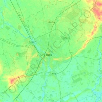
Name: York topographic map, elevation, terrain.
Location: York, York and North Yorkshire, England, United Kingdom (53.87457 -1.22371 54.05687 -0.91967)
Average elevation: 16 m
Minimum elevation: 2 m
Maximum elevation: 57 m
Other topographic maps
Click on a map to view its topography, its elevation and its terrain.
Cambridge
United Kingdom > England > Cambridge
The city, like most of the UK, has a maritime climate highly influenced by the Gulf Stream. Located in the driest region of Britain, Cambridge's rainfall averages around 570 mm (22.44 in) per year, around half the national average, with some years occasionally falling into the semi-arid (under 500 mm (19.69…
Average elevation: 18 m
Salisbury
United Kingdom > England > Salisbury
Bishop of Salisbury Hubert Walter was instrumental in the negotiations with Saladin during the Third Crusade, but he spent little time in his diocese prior to his elevation to archbishop of Canterbury. The brothers Herbert and Richard Poore succeeded him and began planning the relocation of the cathedral into…
Average elevation: 96 m
Leeds
Lying in the eastern foothills of the Pennines, there is a significant variation in elevation within the city's built-up area. The district ranges from 1,115 feet (340 m) in the far west on the slopes of Ilkley Moor to about 33 feet (10 m) where the rivers Aire and Wharfe cross the eastern boundary. Land rises…
Average elevation: 94 m




St Albans
United Kingdom > England > Hertfordshire > St Albans
St Albans was an ancient borough created following the dissolution of the monastery in 1539. It consisted of the ancient parish of St Albans (also known as the Abbey parish) and parts of St Michael and St Peter. The municipal corporation was reformed by the Municipal Corporations Act 1835 and the boundary was…
Average elevation: 100 m

Scafell Pike
United Kingdom > England > Cumberland
Scafell Pike (/ˈskɔːfɛl paɪk/) is the highest and the most prominent mountain in England, at an elevation of 978 metres (3,209 ft) above sea level. It is located in the Lake District National Park, in Cumbria, and is part of the Southern Fells and the Scafell massif.
Average elevation: 679 m
Basingstoke
United Kingdom > England > Hampshire > Basingstoke and Deane
Situated in a valley through the Hampshire Downs at an average elevation of 88 metres (289 ft) Basingstoke is a major interchange between Reading, Newbury, Andover, Winchester, and Alton, and lies on the natural trade route between the southwest of England and London. The area had been something of an…
Average elevation: 109 m
Hull
United Kingdom > England > Kingston upon Hull
Kingston upon Hull is on the northern bank of the Humber Estuary. The city centre is west of the River Hull and close to the Humber. The city is built upon alluvial and glacial deposits which overlie chalk rocks but the underlying chalk has no influence on the topography. The land within the city is generally…
Average elevation: 21 m


Isleworth
United Kingdom > England > Greater London
If deemed to still include Osterley, elevations range from 27 m (89 ft) in the northwest to 4.9 m (16 ft) by the Thames OD. The boundaries are longstanding, subject to twentieth-century western and southern circonscriptions: Isleworth is east of the town of Hounslow which has more retail and offices, in the…
Average elevation: 19 m


Loughrigg Tarn
United Kingdom > England > Westmorland and Furness > Skelwith Bridge
Average elevation: 132 m
Blencathra
United Kingdom > England > Westmorland and Furness > Threlkeld
The Northern Fells make up a roughly circular upland area about 10 miles (16 km) wide. At the centre is the marshy depression of Skiddaw Forest — a treeless plateau at an altitude of 1,300 ft (400 m) — and flowing outward from here are the rivers which divide the area into three sectors. Between the…
Average elevation: 577 m






Shaw
United Kingdom > England > Oldham
Described in Samuel Lewis's A Topographical Dictionary of England (1848) as located in "a bleak situation", Shaw and Crompton is in the valley of the River Beal, which runs northward through the town towards the village of Newhey. The land to the east of the town steadily rises, reaching a height of 1,283 feet…
Average elevation: 224 m

Great Mell Fell
United Kingdom > England > Westmorland and Furness > Matterdale End
Average elevation: 320 m


Alderley Edge
United Kingdom > England > Alderley Edge
Alderley Edge is 6 miles (10 km) northwest of Macclesfield and 15 miles (24 km) south of Manchester, at the base of a steep and thickly wooded sandstone escarpment, Alderley Edge, which is the area's chief topographical feature and overlooks the Cheshire Plain.
Average elevation: 92 m


Farnborough
United Kingdom > England > Hampshire > Rushmoor
Farnborough is located in the northeastern corner of the county of Hampshire, near the border with Surrey. The town occupies a valley setting, with the main urban area situated between the River Blackwater to the east and higher ground to the west. The topography gradually rises from the valley floor, reaching…
Average elevation: 82 m
South Shields
United Kingdom > England > Tyne and Wear > South Tyneside
The current town was founded in 1245 and developed as a fishing port. The name South Shields developed from the 'Schele' or 'Shield', which was a small dwelling used by fishermen. Another industry that was introduced, was that of salt-panning, later expanded upon in the 15th century, polluting the air and…
Average elevation: 23 m



Coalville
United Kingdom > England > Leicestershire > North West Leicestershire
Average elevation: 149 m



Weston-super-Mare
United Kingdom > England > North Somerset > Weston-super-Mare
Average elevation: 13 m