
Taunton topographic map
Interactive map
Click on the map to display elevation.
About this map
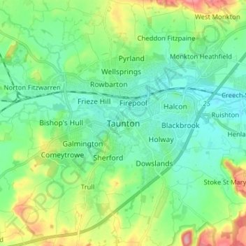
Name: Taunton topographic map, elevation, terrain.
Average elevation: 39 m
Minimum elevation: 7 m
Maximum elevation: 122 m
Other topographic maps
Click on a map to view its topography, its elevation and its terrain.
Thorne St Margaret
United Kingdom > England > Somerset > Somerset West and Taunton > Holywell Lake
Thorne St Margaret, Wellington Without, Holywell Lake, Somerset West and Taunton, Somerset, England, TA21 0EQ, United Kingdom
Average elevation: 94 m