
Stanmer topographic map
Interactive map
Click on the map to display elevation.
About this map
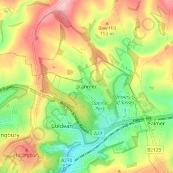
Name: Stanmer topographic map, elevation, terrain.
Location: Stanmer, Brighton and Hove, England, BN1 9PZ, United Kingdom (50.85099 -0.12195 50.89099 -0.08195)
Average elevation: 119 m
Minimum elevation: 38 m
Maximum elevation: 209 m
Other topographic maps
Click on a map to view its topography, its elevation and its terrain.
Portslade by Sea
United Kingdom > England > Brighton and Hove
Portslade by Sea, Brighton and Hove, England, BN41 1GB, United Kingdom
Average elevation: 35 m
Patcham
United Kingdom > England > Brighton and Hove
Patcham, Brighton and Hove, England, BN1 8QF, United Kingdom
Average elevation: 98 m
Brighton
United Kingdom > England > Brighton and Hove > Brighton
Brighton, Brighton and Hove, England, United Kingdom
Average elevation: 64 m