
Cuttack topographic map
Click on the map to display elevation.
Cuttack
Cuttack is located at 20°31′23″N 085°47′17″E / 20.52306°N 85.78806°E / 20.52306; 85.78806 and has an average elevation of 36 metres (118 ft). The city is spread across an area of 192.5 km2 (74 sq mi). The city is a Cuttack Municipal Corporation, which consists of 59 wards. The city stretches from Phulnakhara in south to Choudwar in north and Kandarpur in east to Naraj in west, while the main city is located at the apex of the Mahanadi River delta. Apart from Mahanadi, four of its distributaries also run through the city. The distributaries include Mahanadi, Kathajodi, Kuakhai, and Birupa, where Kathajodi further has two distributaries, the right being Devi while the left is Biluakhai. Mahanadi runs through the city on the northern side, separating the main city from the Jagatpur Industrial Area. The Kathajodi River forms a riverine island of Bayalis Mouza (42 Wards) after separating the main city from Gopalpur. The Kuakhai River separates the southern part of the city into two halves, namely Pratap Nagri and the new township of Naranpur. The Kuakhai runs throughout the south of the city along Phulnakhara before entering Bhubaneswar. The Birupa river runs through the north of Jagatpur Industrial Area, separating it from Choudwar. There are numerous ponds known as (pokharis) in the city that store rainwater. The Mahanadi provides much of the drinking water to the city. Recent growth of the city has resulted in expansion across the Kathajodi River, and a newer township towards the head of the delta formed between the tributary Kathajodi river and the main river Mahanadi has come up by the name of Markat Nagar (popularly known as CDA by the local residents), which is spread across 2000 acres. CDA has 15 sectors out of which 11 are residential and has a population of around 150,000. Jagatpur and Mahanadi Vihar are the other two townships in the city. Mahanadi Vihar is the first satellite city project in Odisha. Cuttack is referred to as a city with Baaban Bazaar, Teppan Galee, i.e., this is the city of 52 markets and 53 streets, which is told by people of Odisha for the largeness of this city. Naranpur is another satellite township coming up in Trishulia, on the other side of the Kathajodi River.
About this map
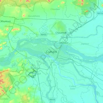
Name: Cuttack topographic map, elevation, terrain.
Location: Cuttack, Cuttack (M.Corp.) P.S, Cuttack, Odisha, 753001, India (20.30860 85.71920 20.62860 86.03920)
Average elevation: 34 m
Minimum elevation: 7 m
Maximum elevation: 223 m