Santarém topographic map
Interactive map
Click on the map to display elevation.
About this map
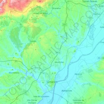
Name: Santarém topographic map, elevation, terrain.
Location: Santarém, Portugal (39.16875 -8.89945 39.48301 -8.55690)
Average elevation: 78 m
Minimum elevation: 2 m
Maximum elevation: 520 m
Other topographic maps
Click on a map to view its topography, its elevation and its terrain.
Achete, Azoia de Baixo e Póvoa de Santarém
Portugal > Santarém > Santarém
Achete, Azoia de Baixo e Póvoa de Santarém, Santarém, 2000-343, Portugal
Average elevation: 78 m
Arneiro das Milhariças
Portugal > Santarém > Santarém
Arneiro das Milhariças, Santarém, Portugal
Average elevation: 103 m