
Make a donation
Pinetown topographic map
Click on the map to display elevation.
Make a donation
Pinetown
Topographically, Pinetown is generally hilly with the exception of the central business district which is relatively flatter by comparison to the surrounding suburban areas. The notable high-lying areas in the eastern parts of Pinetown include Cowies Hill and the New Germany Nature Reserve reaching approximately 400 m (1312 ft) above sea level. In the northern parts, the suburb of Berkshire Downs in New Germany reaches approximately 393 m (1289 ft) above sea level. The lowest elevations of Pinetown are found in the southern parts, which approximately range between 170 m (558 ft) and 300m (984 ft) above sea level.
Make a donation
About this map
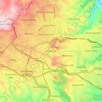
Name: Pinetown topographic map, elevation, terrain.
Average elevation: 296 m
Minimum elevation: 13 m
Maximum elevation: 554 m
Make a donation
Other topographic maps
Click on a map to view its topography, its elevation and its terrain.
Pigeon Valley
South Africa > KwaZulu-Natal > eThekwini Metropolitan Municipality > Durban
Average elevation: 69 m
eThekwini Ward 32
South Africa > KwaZulu-Natal > eThekwini Metropolitan Municipality
Average elevation: 25 m
Bluff Nature Reserve
South Africa > KwaZulu-Natal > eThekwini Metropolitan Municipality > Durban
Average elevation: 38 m
Make a donation
uMngeni River
South Africa > KwaZulu-Natal > eThekwini Metropolitan Municipality
Average elevation: 598 m
Umgeni River
South Africa > KwaZulu-Natal > eThekwini Metropolitan Municipality > Queensburgh
Average elevation: 131 m
Umbilo River
South Africa > KwaZulu-Natal > eThekwini Metropolitan Municipality > Durban
Average elevation: 56 m
Umbilo River
South Africa > KwaZulu-Natal > eThekwini Metropolitan Municipality > Durban
Average elevation: 56 m
Make a donation
Umgeni River
South Africa > KwaZulu-Natal > eThekwini Metropolitan Municipality > Queensburgh
Average elevation: 131 m
Inanda Dam
South Africa > KwaZulu-Natal > eThekwini Metropolitan Municipality
Average elevation: 222 m
uMngeni River
South Africa > KwaZulu-Natal > eThekwini Metropolitan Municipality
Average elevation: 598 m
Make a donation
Plantations
South Africa > KwaZulu-Natal > eThekwini Metropolitan Municipality > Hillcrest
Average elevation: 631 m