
Thank you for supporting this site ❤️
Make a donation
Make a donation
Mação topographic map
Click on the map to display elevation.
Thank you for supporting this site ❤️
Make a donation
Make a donation
About this map
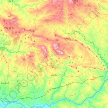
Name: Mação topographic map, elevation, terrain.
Location: Mação, Santarém, Portugal (39.46940 -8.10831 39.74783 -7.80899)
Average elevation: 275 m
Minimum elevation: 23 m
Maximum elevation: 634 m
Thank you for supporting this site ❤️
Make a donation
Make a donation
Other topographic maps
Click on a map to view its topography, its elevation and its terrain.