
Thank you for supporting this site ❤️
Make a donation
Make a donation
Roosendaal topographic map
Click on the map to display elevation.
Thank you for supporting this site ❤️
Make a donation
Make a donation
About this map
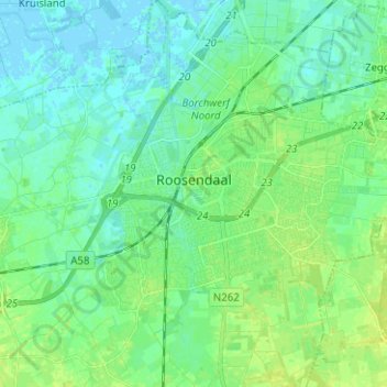
Name: Roosendaal topographic map, elevation, terrain.
Location: Roosendaal, North Brabant, Netherlands (51.49127 4.40694 51.56923 4.52319)
Average elevation: 5 m
Minimum elevation: -2 m
Maximum elevation: 12 m
Thank you for supporting this site ❤️
Make a donation
Make a donation
Other topographic maps
Click on a map to view its topography, its elevation and its terrain.