
Thank you for supporting this site ❤️
Make a donation
Make a donation
Vertou topographic map
Click on the map to display elevation.
Thank you for supporting this site ❤️
Make a donation
Make a donation
About this map
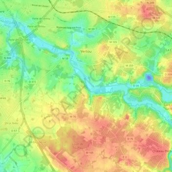
Name: Vertou topographic map, elevation, terrain.
Average elevation: 31 m
Minimum elevation: -38 m
Maximum elevation: 62 m
Thank you for supporting this site ❤️
Make a donation
Make a donation
Other topographic maps
Click on a map to view its topography, its elevation and its terrain.
Thank you for supporting this site ❤️
Make a donation
Make a donation
Le Champsiome
France > Pays de la Loire > Loire-Atlantique > Pont-Saint-Martin
Average elevation: 24 m
Thank you for supporting this site ❤️
Make a donation
Make a donation
Thank you for supporting this site ❤️
Make a donation
Make a donation
Le Petit Haut Bodio
France > Pays de la Loire > Loire-Atlantique > Pontchâteau
Average elevation: 21 m
Thank you for supporting this site ❤️
Make a donation
Make a donation
Le Hameau du Petit Raffuneau
France > Pays de la Loire > Loire-Atlantique > Orvault
Average elevation: 51 m
Thank you for supporting this site ❤️
Make a donation
Make a donation
La Vilhouette
France > Pays de la Loire > Loire-Atlantique > Loireauxence > La Vilhouette
Average elevation: 18 m
Thank you for supporting this site ❤️
Make a donation
Make a donation