
Hartlepool topographic map
Interactive map
Click on the map to display elevation.
About this map
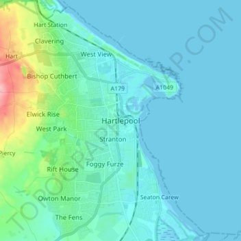
Name: Hartlepool topographic map, elevation, terrain.
Location: Hartlepool, Tees Valley, England, TS24 7EQ, United Kingdom (54.64573 -1.24937 54.72573 -1.16937)
Average elevation: 16 m
Minimum elevation: -2 m
Maximum elevation: 118 m
Other topographic maps
Click on a map to view its topography, its elevation and its terrain.
Wynyard
United Kingdom > England > Hartlepool
Wynyard, Hartlepool, Tees Valley, England, United Kingdom
Average elevation: 67 m
Elwick
United Kingdom > England > Hartlepool
Elwick, Hartlepool, Tees Valley, England, United Kingdom
Average elevation: 59 m
Teesmouth
United Kingdom > England > Hartlepool
Teesmouth, Hartlepool, Tees Valley, England, TS10 5NX, United Kingdom
Average elevation: 1 m
Greatham
United Kingdom > England > Hartlepool
Greatham, Hartlepool, Tees Valley, England, United Kingdom
Average elevation: 12 m
Seaton Carew
United Kingdom > England > Hartlepool
Seaton Carew, Hartlepool, Tees Valley, England, TS25 1BT, United Kingdom
Average elevation: 4 m