
Wayne County topographic map
Interactive map
Click on the map to display elevation.
About this map
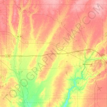
Name: Wayne County topographic map, elevation, terrain.
Location: Wayne County, Indiana, USA (39.71448 -85.22151 40.00660 -84.81081)
Average elevation: 322 m
Minimum elevation: 241 m
Maximum elevation: 385 m
Other topographic maps
Click on a map to view its topography, its elevation and its terrain.
Maple Lane
USA > Indiana > Maple Lane
Maple Lane, Saint Joseph County, Indiana, 46617:46635, USA
Average elevation: 229 m
Mount Etna
USA > Indiana > Mount Etna
Mount Etna, Huntington County, Indiana, USA
Average elevation: 245 m
Middle Fork of Wildcat Creek
Middle Fork of Wildcat Creek, Clinton County, Indiana, 46065, USA
Average elevation: 215 m